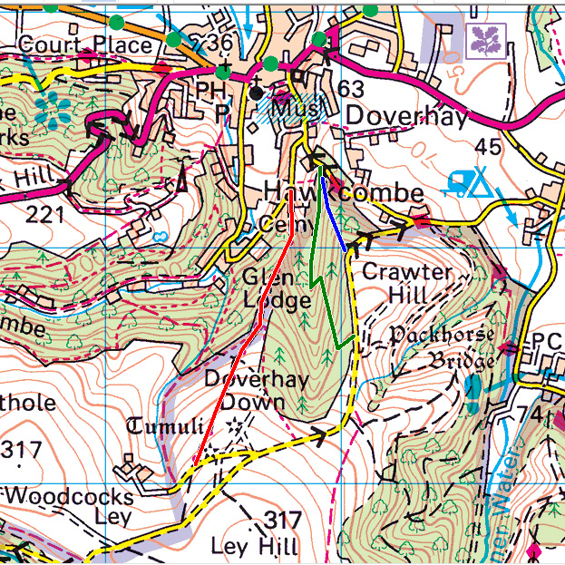
So where, exactly, is the section known as Doverhay, used for the Brighton & Hove Motor Club’s Brighton-Beer Trial in 1933, and for the MCC’s Lands End Trial (generally for motorcycles only) from 1932 to 1957 (and maybe later)?

Is it:
- Doverhay Road (USRN: 43786546), shown on the map above as a red line?
- Bridleway WL19/17, shown on the map above as a green line?
- Footpath WL19/16, shown on the map above as a blue line?
- … or somewhere else in this area?
I’ve read lots of previous reports, including extensive correspondence in the MCC News of the Week back in May 2010, but nothing has been accurate enough to distinguish between the three tracks I list above. Can anyone help?
Update 26 September 2019 18:30:
Simon Woodall posted a short piece, with a link to this post, in the MCC News of the Week 21.09.2019, and this generated responses from four MCC members, so my thanks to Neil Browne, Colin Butchers, Martyn Halliday, and Rick Howell. Piecing-together information from all four, I’m now pretty certain that the line of the section is along none of the coloured lines in the above map, although it’s closest to the Red Line.
The current best-guess is that it is a track not shown on the current OS maps (but clearly visible on the 1903 and 1949 maps and, I’m told, on the ground), which deviates from Doverhay Road (the Red Line) around OS GR SS 8879 4602 and rejoins it higher-up, around OS GR SS 8866 4566, after passing through the right-left hairpin bends which feature in the period photographs along the way. The top of Doverhay Road, where it rejoins the tarmaced ‘yellow’ road high-up on Ley Hill, certainly matches the description in the MG Magazine article linked here, whereas the top of the bridleway (Green Line) does not. Look at this point (around OS GR SS 8838 4508) on Google Street View and you can clearly see the village of Porlock and the mountains of Wales as described by H E Symons in the MG Magazine.
So … what we need now is to find a route card with more detail than the ones I have seen, which merely record the turn off the (current) A39 and assume that the drivers and riders know their way from there to the section!
… later the same day …
Neil Browne has sent me a copy of the route card for the 1957 Lands End Trial, which clearly states that competitors should turn Right at the fork in the ‘yellow’ roads as they exit the village towards the section, so another piece in the puzzle pointing towards the best-guess route above, and not the ‘Green Line’ bridleway route.