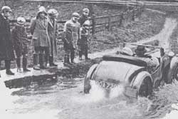
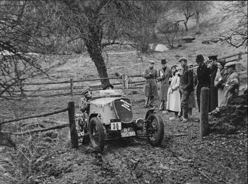
 The Woodalls, Bertie (driving in the cap) and Victor (passengering in the fedora), in Victor’s Wolseley Ford special at the start of ‘New Kineton’ on the 1939 Colmore Trial. With many thanks to Simon Woodall for providing both the original photographs.
Although Juniper might be considered a very obvious candidate for the first in this series, the choice of the comparatively little-known section of Kineton for the second – first published, on my “Section Begins” website, in November 2001 – warrants rather more explanation. Sometimes the search for historic sections is quite easy. It’s often possible to compare a description in Wheelspin, a map in one of the PreWar copies of Light Car, and the current OS map, to come up with a pretty good idea of where a particular section might be. Then a visit, with old photographs for reference, will complete the research. But tracking-down Kineton was not that easy, by a long way!
Data – Kineton (Old)
| County | OS 100km | GR Entry | GR Start | GR Exit |
| Gloucestershire | SP | 098267 | 098267 | 097265 |
| ROW Status | ID Number | First used | Last used | View map? |
| ‘Track’ | None | 1929? | 1938? | Click here |
Data – Kineton (New)
| County | OS 100km | GR Entry | GR Start | GR Exit |
| Gloucestershire | SP | 098267 | 098267 | 097266 |
| ROW Status | ID Number | First used | Last used | View map? |
| Footpath | FP22 | 1935 | 1952? | Click here |
History
Donald Cowbourne lists Kineton as used by SUNBAC for the ‘Colmore’ trials of 1929, 1930, and 1933 to 1939 inclusive, and for the NWLMC ‘Gloucester’ trials of 1933 to 1938 inclusive, but without differentiating between the two sections. I’m also fairly certain that SUNBAC had used it before 1929 but whether this was for the motorcycle Colmore ‘Cup’ rather than the car Colmore ‘Trophy’, I’m not sure (… and I’ve not yet checked Donald Cowbourne’s 1919 to 1929 volume). In Wheelspin May states that the 1935 ‘Colmore’ was the first use of New Kineton so it is a reasonable assumption that all PreWar events from then on used the ‘new’ section and it was definitely used for the 1946 and 1947 ‘Colmores’.
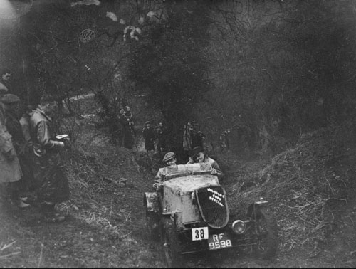 The Woodalls further up the section on the 1939 Colmore Trial.
Apparently they have just failed the section after the pedal assembly ‘fell off’.
More history
Kevin Barnes provided me with four photographs from the 1935, 38, 49, and 50 ‘Colmores’ although, unfortunately, three of them do not reproduce well enough to be worth including here. However I do think the fourth one, of the Austin 7 (below), more than compensates with its wonderfully evocative image of 1930s trialling. Arthur Vowden sent me two photographs from David Kinsella’s book on the Allard but they’re not captioned and I’m not sufficiently sure that they are Kineton to include here, although one does look remarkably similar to the picture of the same car in May’s ‘More Wheelspin’.
Kevin also provided me with more information on the Post-War use of Kineton. In addition to the ’46 and ’47 ‘Colmores’, we’re sure, from contemporary events reports, that Kineton was used for the ‘Colmore’ in ’49, ’50 and ’51.
Discovering Kineton
The small Cotswold village of Kineton sits on a minor road linking the larger villages of Temple Guiting and Guiting Power and, apart from the excellent ‘Halfway House’ pub, it’s only notable features are the two (rather deep) fords on an even more minor road in the valley to the east of the village. None of the climbs out of these fords appear steep enough to have been ‘stoppers’, even allowing for a typical 1930s surface, and the 1:50,000 Landranger map reveals no other obvious ‘trials’ tracks – not even a bridleway or a footpath. So how come this little village gave the Pre War triallers not one but two sections?
Kineton is mentioned several times in both Austen May books, including a detailed description of the ‘new version’ of Kineton in Wheelspin and a 1947 photograph in More Wheelspin, but even these were of no real help in locating either of the sections. I’d even spotted a photograph, of a car very obviously ascending a trials hill, hanging on the wall in the bar of the ‘Halfway House’ but at the time no one seemed to know where it had been taken so I was none the wiser. Tracking-down the two Kineton sections was becoming a bit of an obsession but, without any new information, the search was put on hold.
Some years later, passing through the village, I noticed a new ‘Public Path’ sign pointing down a track that was not even marked on the Landranger map. It was far too narrow for a car, and I was tempted to drive on, but everything began to click into place. I drove down into the bottom of the valley, through one of the fords, then along the narrow lane leading to the other ford. There, sure enough, was the matching new ‘Public Path’ sign pointing up a very obvious track that I had always taken to be a private drive. But it still wasn’t steep enough to justify May’s comments as to “the very real difficulty of Kineton”. [Note: December 2021. This Public Path is ‘Old’ Kineton.]
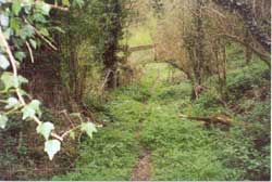
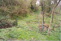
Not long afterwards, I happened to mention my ongoing search to Simon Woodall. “I think I’ve got a picture of my father on Kineton” he said and just a couple of days later the two photographs featured on this page arrived. The first picture showed, quite clearly, both the ‘massive’ gate-posts referred to so specifically in Wheelspin and, in the background, the river which runs through the two fords. Surely it must now be possible to locate the sections? Once again I revisited the village, starting in the valley and walking up the ‘Public Path’. The track had been cleared since my previous visit and there, just as described by May, was the gate and the gate posts. But now there was also a brand-new ‘Public Footpath’ sign pointing through the gate and up the hill. Forcing my way up the steep and totally-overgrown track it was just about possible to make comparisons with the second of Simon’s photographs showing the two Woodalls on the upper part of the section. This footpath was, quite clearly, ‘New’ Kineton.
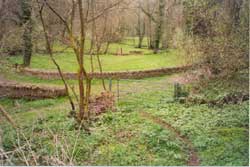
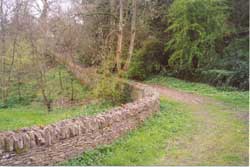
Photographs – Then and Now
Visiting Kineton
Neither section is marked on OS Landranger Map No. 163. Park somewhere near the ‘Halfway House’ on the main road through the village. Facing the front of the pub, turn right, walk along about 100 yards and turn left where signed downhill towards a ford. Go through the ford (there is a footbridge) and continue along the road parallel to the river turning left where there is a small grassed triangle. As the road bears round to the right, approaching the other ford, you’ll see the ‘Public Path’ clearly marked on the left. Go through the gate and over the river.
The ‘old’ (Pre 1935) section follows the public path as it bears round to the left and climbs between stone walls before a sharp right turn back to the road by the pub. The ‘new’ (Post 1935) section “branches off to the right immediately at the foot of the hill … entered at rather an awkward angle through a gate.” (May’s 1935 description is still accurate.) The now-signed, but overgrown, footpath climbs steeply although, just at the very top, it’s now diverted from its original route by new housing. At the top of both sections you’re back on the main road through the village within sight of the pub.
This Post was originally published on 30 December 2015 as a Page on this website and is re-posted here with minor updates and amendments.
