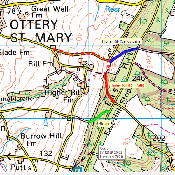
This is, I’m afraid, one for the real historic trials sections nerds. Back in May 2022, Jonathan Toulmin and I were trying to confirm the location of a photograph, taken on the 1939 Exeter Trial, of his father, Maurice Toulmin, in the Cream Cracker MG TA Reg.No. BBL 78. It was noted as Higher Rill but the lie of the land did not match Jonathan’s recollection of the section called Higher Rill which featured on the Exeter Trial in the mid 2000s.
After a lot of research and head-scratching it became apparent that there were two sections, shown on the map above in red and blue. I have also included the nearby Stretes for reference, shown on the map above in green.
Higher Rill (also called Rill Path). Although described as a road on the NSG, it has a questionable legal status, so must be treated as Private. [NSG USRN: 12105292].
Sandy Lane (also called Higher Rill and Rill Path). This is Ottery St Mary Footpath No.19. [NSG USRN: 12108780].
Exeter Trial 1929 to 1985
The red line above shows the historic Higher Rill section as used for the Exeter Trials of 1929-1931, 1938-1939, 1950-1951, and 1984-1985. I have the route cards for 1930, 1950, and 1984 which confirm the route and I’m assuming that it must have been the same for the other years. The 1930 and 1950 route instructions are almost identical, the only significant difference being that the NON-STOP section in 1930 started way back on the road from Ottery St Mary, and is shown above as a dotted red line, whereas the 1950/1984 section starts much higher up and is shown as a solid red line. Both the 1930 and 1950 instructions state “L following (telegraph) wires” (where the dotted red line starts) and, amazingly, these wires are still visible on the latest (2021) Google Street View. The 1984 route approached from the north east (via the now-declassified B3174) but definitely used the same section as 1930 and 1950.
Exeter Trial 2003 to 2020
Unfortunately, when the MCC returned to the Higher Rill area from 2003, the section naming all got a lot more complicated.
2003 Exeter. The Main Trial used Sandy Lane (named as Higher Rill), approached from the top of Stretes, descending the historic Higher Rill. Class 0 by-passed the section.
2004 to 2006 Exeter. The Main Trial, and Class 0, used Sandy Lane (named as Higher Rill), approach not checked.
2007 to 2008 Exeter. The Main Trial, and Class 0, used Sandy Lane (named as Higher Rill), approached from the top of Stretes, descending the historic Higher Rill.
2009 to 2012 Exeter. The Main Trial used the historic Higher Rill section (renamed as Rill Path), approached from the north east as for 1984. 2012 was the last year that the historic section was used, and also the last year that the Main Trial visited the Higher Rill area.
2009 to 2012 Exeter. Class 0 used Sandy Lane (the ‘new’ section which the MCC had called Higher Rill from 2003 to 2008), approached from the north east as for the Main Trial.
2013 to 2015 Exeter. Class 0 used Sandy Lane (but named as Rill Path), approached from the north east.
2016 to 2020 Exeter. Class 0 used Sandy Lane, approached from the north east.
… and if anyone thinks they know better, please Contact Me using the email link in the right-hand sidebar.
Ω